


What is a national monument, anyway? That’s what I kept asking myself as I rode a mountain bike down a rocky trail on sedimentary layers in the Grand Canyon-Parashant National Monument. I was rapidly approaching a lower point on the northern rim of the canyon, which is more than a mile deep at some sections. I stopped 2,000 feet above the bottom of the gorge and watched the Colorado River curve through steep cliffs.
The scenery is stunning, the landscape huge…so how is it different than a national park? Turns out, not all that much, at least from a visitor’s standpoint. Most national monuments protect vast landscapes of environmental, cultural, or scenic importance. Ditto national parks.
The real difference is how they’re created: national parks are voted into place by Congress, national monuments are designated by presidents via the Antiquities Act. With monuments there’s less red tape, but sometimes more drama (see Bears Ears, below). Also, while many national monuments are managed by the park service, some are managed by the U.S. Forest Service and others are run by the Bureau of Land Management.
There are 133 national monuments scattered across the U.S., usually no less magnificent than their more famous national-park cousins. Sometimes they have fewer amenities (many lack visitor centers, some have no paved roads), and most of them have fewer crowds. Traveling more than 100 miles around Grand Canyon-Parashant National Monument last May, I never saw anyone outside of my own group. That would not have been the case in Grand Canyon National Park. Meanwhile the adventure was just as epic.
I’ve gathered 11 of the greatest national monuments in the country, from green mountains on the East Coast to canyons full of cliff dwellings in the Southwest, to fields of wildflowers on the West Coast. Most of these monuments aren’t famous, but all deserve to be on your bucket list.
Katahdin Woods and Waters National Monument, Maine
Katahdin Woods and Waters National Monument includes 30 miles of the internationally known Appalachian Trail. (Photo: Courtesy NPS)
Katahdin Woods and Waters encompasses 87,563 acres of remote mountains, rivers, and backcountry ponds in northern Maine, sustaining healthy populations of moose and black bears. The monument sits to the east of Baxter State Park, where the Appalachian Trail finishes on top of 5,269-foot Mount Katahdin.
While this neighbor park hosts the last, most difficult gasp of the “A.T.,” Katahdin Woods and Waters has 30 miles of the International Appalachian Trail (a northerly variant that begins here and extends through New Brunswick, Quebec, and a ferry route to Newfoundland), along with a tumultuous portion of the East Branch of the Penobscot River, which flows for 25 miles south through the monument, dropping more than 200 feet in its first 10 miles in a series of waterfalls. Cross-country skiing is popular during the winter; hiking rules in the summer.
Best Hiking Trails in Katahdin Woods and Waters National Monument (Photo: Courtesy Gaia GPS)
Adventure: If you want a quick taste of the monument, the 17-mile Katahdin Loop Road offers short hikes and grand scenic overlooks. But to truly experience Katahdin Woods and Waters, tackle the 10-mile round-trip hike to the summit of Deasey Mountain via a portion of the Appalachian Trail. You’ll have to ford the thigh-deep Wassataquoik Stream and climb almost 1,600 feet, but 360-degree views and a historic fire tower reward you at the 1,942-foot summit. The monument is primitive, without a lot of developed facilities (nor any flush toilets). There are 15 free campsites, but you need reservations.
Grand Staircase-Escalante National Monument, Utah
Burr Trail in Grand Staircase-Escalante National Monument (Photo: Jim Thomsen)
Sandwiched between Bryce Canyon and the Grand Canyon, Grand Staircase Escalante gets its name from the series of plateaus that descend between those two massive and scenic ditches. Not to be outdone by its more famous neighbors, which cover 36,000 and 1.2 million acres respectively, Grand Staircase is nearly 1.9 million acres of colorful sandstone canyons, cliffs, and arches.
Spooky Canyon Loop via Peek A Boo & Spooky Trail (Photo: Courtesy Gaia GPS)
Adventure: Connecting Peek-a-Boo and Spooky Slot Canyons in the Dry Fork area of Grand Staircase-Escalante makes for the perfect entry into this unique terrain. It’s a three-mile loop, but plan on a whole afternoon exploring the narrow red- and purple-walled gulches. Some of the passages in Spooky get tight, and there is mandatory scrambling, but no technical climbing is required. If you want to explore more technical canyons, Excursions of Escalante has been guiding canyoneering trips in the monument for more than two decades, and offers a rotating roster of full-day adventures packed with rappels (from $225 per person).
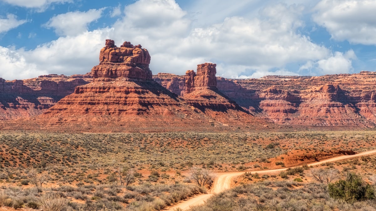
Bears Ears National Monument, Utah
The bear’s-ears-shaped buttes that give Bear Ears National Monument its name (Photo: Courtesy EcoFlight)
Named after twin buttes rising from the desert floor of Southeastern Utah, Bears Ears National Monument has seen more than its share of debate since it was established by President Obama in 2016. The 1.36-million-acre monument is a place of scenic glory and cultural significance: massive red rock cliffs and canyons abound, and a bevy of Native American historical artifacts, from cliff dwellings to pictographs, have been found here.
Today, the Ute Mountain Ute Tribe, Navajo Nation, Hopi Tribe, Ute Indian Tribe, and Zuni Tribe all participate in stewardship of Bears Ears as a sacred place. In 2022, the Biden administration signed an agreement that gives those five tribes input into management of the area, and the five Tribes of the Bears Ears Commission (the Commission) and federal agencies released a draft management plan this year. As for recreation, the Indian Creek Unit, in the northern section of Bears Ears, is a mecca for climbers, who come for the seemingly endless number of cracks in the red rock cliffs. Hikers and bikers follow trails and view artifacts across the region.
The author and friends on a ride in Bears Ears National Monument. (Photo: Graham Averill)
Adventure: Bears Ears holds world-class climbing. Sadly, I’ve never climbed in the area (it’s on my list), but I’ve bike-packed through the monument and was awestruck by the sheer volume of towering rock. There are thousands of climbing routes, though not many for beginners. Supercrack Buttress has a high percentage of classic climbs, including the historic Supercrack of the Desert, a sustained and strenuous 5.10+. Consider a full-day guided climbing adventure in Indian Creek with the Moab-based Cliffs and Canyons (from $220 per person).
Comb Ridge, in the southeastern part of Bears Ears National Monument. This aerial image shows the variety as well as beauty of the historically and culturally significant area. (Photo: Courtesy EcoFlight)
To see some of the cultural artifacts within Bears Ears, hike an easy five-mile out and back through Mule Canyon where the payoff is access to a series of cliff dwellings tucked into a sandstone overhang. The most notable home has been dubbed “house on fire,” because of the fire-red-toned rock that forms its ceiling. The hike itself is relatively flat as it traverses the dry gorge, with some optional scrambling up sandstone slopes at the end.
There are three designated campgrounds in Indian Creek, all first-come, first-served ($15 a night). Hamburger Rock has 10 sites tucked into mushroom-shaped outcroppings. Always bring plenty of water; there’s no potable water at any of the established campgrounds.
Devils Tower National Monument, Wyoming
The monolith of Devils Tower rises from the prairie, seen across the sagebrush from Joyner Ridge Trail. (Photo: Courtesy Avery Locklear/NPS)
Created by Theodore Roosevelt in 1906, Devils Tower was the first national monument in the country, and it’s still one of the most distinctive. The center of the monument is Devils Tower, a solitary butte rising almost 900 feet from the prairie. The monument is not large, at just 1,346 acres, and there are only five hiking trails within the designated area, and all can be combined for a full day of hiking. Tackling only the 2.8-mile Red Beds Trail will give you a good sense of the landscape, as it delivers views of the massive tower and the more serene Belle Fourche River Valley.
Adventure: Climbers have been drawn to Devils Tower for many decades. Parallel cracks divide the formation into large hexagonal columns, and create a variety of crack and corner climbs for experienced traditional climbers. Routes range from 5.7 to 5.13. Durrance, a 500-foot, six-pitch 5.7, is widely considered the easiest way to the summit. Register your climb at the trailhead to Tower Trail, the approach to the monolith, and heed the June voluntary climbing closure, which was implemented out of respect for Native American tribes associated with the tower, which perform ceremonies at the tower during the month. Belle Fourche Campground has 46 first-come, first-served sites under cottonwood trees ($20 per night).
Dinosaur National Monument, Colorado and Utah
The mouth of Sand Canyon on the Yampa River, Dinosaur National Monument (Photo: Courtesy NPS)
Dinosaur preserves 210,000 acres of western Colorado and eastern Utah, where the mighty Green and Yampa rivers converge, creating 2,500-foot-deep canyons. Within the monument are whitewater rapids, red rock canyons, dinosaur fossils encased in rock, and 1,000-year-old petroglyphs and pictographs left by the Fremont people. You can get a sense of the monument by car; Harpers Corner Road is a 32-mile one-way scenic road with views of the Green and Yampa rivers.
If you have a 4WD, peel off the paved road and head to the Echo Park area, the monument’s signature landscape where the Yampa flows into the Green and the conjoined river wraps around the massive Steamboat Rock. There’s a picnic table if you just want to take in the view, or you can camp (see below).
Rafters approach Tiger Wall on the Yampa River, Dinosaur National Monument (Photo: Courtesy NPS)
Adventure: Raft the Green River through the heart of the monument. The classic run starts at the Gates of Lodore in Colorado and ends at the Split Mountain Campground in Utah. It’s a class III trip, appropriate for families. Adrift Dinosaur runs four-day trips with catered meals (from $1,499 per adult). There are six established campgrounds, all of which are located on either the Green or Yampa rivers, within the monument. Echo Park has a small campground with 22 sites, first-come, first-served ($10 per site).
Grand Canyon-Parashant National Monument, Arizona
Grand Canyon-Parashant National Monument sits on the northern edge of the Grand Canyon, in Arizona, and is as spectacular as the national park with fewer crowds. (Photo: Graham Averill)
While Grand Canyon National Park encompasses arguably the most dramatic swath of “the great ditch,” the Grand Canyon-Parashant National Monument lays claim to more than 1 million acres in northern Arizona, including the less crowded and still awe-inspiring northern stretch of the Grand Canyon. The terrain is a mix of Mojave desert, ponderosa pine forest, broad plateaus, and deep canyons.
Just traveling through the monument is an adventure, as there are no paved roads, only 4WD routes and hiking trails. Don’t come looking for a visitor center or developed campgrounds. You’re on your own. I spent a few days driving ATVs, biking, trail running, and camping in and around this monument and was amazed at the views and solitude.
Adventure: If you have a high-clearance 4WD, Grand Canyon-Parashant offers nearly limitless options. Try the 80-mile trek to Twin Point Overlook, which passes through ponderosa pine forest and fields of grazing cattle on its way to a three-sided perch on the North Rim of the Grand Canyon, with views of Sanup Plateau, Burnt Canyon, and Surprise Canyon. The dirt road turns to clay as it approaches the Grand Canyon, which can be impassable after a heavy rain. There are a number of primitive campsites along the rim of the canyon; only pitch a tent in sites with existing fire rings.
There aren’t a lot of designated hiking trails within the monument, but check out the six-mile out-and-back up Mount Dellenbaugh, which leads to a doozy of a view of the Grand Canyon. The trail follows an old roadbed up the side of the 7,072-foot peak crossing over chunky, volcano rock towards the summit. On a clear day you can see Mt. Charleston, outside of Las Vegas, on the horizon, as well as the western end of the Grand Canyon.
Colorado National Monument, Colorado
Lindsay Herlinger climbs the historic and plenty exciting Otto’s Route (5.8) to the top of Independence Monument, Colorado National Monument. (Photo: Johann Aberger)
High on the Colorado Plateau, near Grand Junction, the 20,533-acre Colorado National Monument could be considered a mini Grand Canyon, as the red rock canyons the monument encompasses are full of towers and rock formations, like the puffy-looking Coke Ovens pinnacles. You can glimpse much of the monument from the 23-mile Rim Rock Drive, which runs along the edge of the canyon with near-constant high views.
The desert spire of Independence Monument, Colorado National Monument, in Western Colorado near Grand Junction (Photo: Graham Averill)
Adventure: Climbing Independence Monument, a sandstone spire that rises 450 feet from the heart of the canyon, might be the signature adventure in the monument. A number of different routes ascend the tower, most of them four to five pitches, followed by a double rappel to descend. The 5.8 Otto’s Route is the classic line. Glenwood Climbing Guides leads day trips up Independence (from $375 for the first climber). Saddlehorn Campground has 80 sites, with half first-come, first-served, while the other half can be reserved in advance ($22 a night).
A number of short hikes begin at Rim Rock Drive. Devils Kitchen Trail is my favorite, as the 1.5-mile out and back leads through some impressive sandstone outcroppings, including the Devils Kitchen, a large natural opening surrounded by towering upright boulders.
Misty Fjords National Monument Wilderness, Alaska
Mountains and waterfalls in Misty Fjords National Monument, 22 miles from the port city of Ketchikan, Alaska. (Photo: Peter Plottel/Getty)
Misty Fjords is quintessential Alaska: 2.2 million acres of rainforest, coastal cliffs, and narrow fjords where glacier-carved rock walls rise 3,000 feet from the sea. In this monument, part of the Tongass National Forest in Southeast Alaska, waterfalls drop directly into the bay, while backcountry lakes and streams are surrounded by thick vegetation. Most people experience Misty Fjords via a scenic flight or boat cruise from nearby Ketchikan, but kayakers have free rein.
Kayaking in the green-blue waters of Misty Fjords National Monument, amid sea cliffs and rock walls soaring 3,000 feet above (Photo: Barry Winiker/Getty)
Adventure: Kayaking is the best way to explore this monument, with its complex shores and many secluded coves. The Behm Canal, a natural channel of calm water carved by glaciers, slices through the heart of Misty Fjords like a highway for boaters. On the east end of the canal, Walker Cove and Punchbowl Cove, where 3,000-foot granite walls rise from the edges of the water, are popular boater destinations with day hikes leading from rocky beaches.
Punchbowl Lake Trail is a two-mile out and back that climbs through the rainforest to a small lake with its own granite walls forming a ring around it. Southeast Exposure runs a six-day guided kayaking trip into Misty Fjords that will have you paddling up to 12 miles a day, hiking to interior lakes, and camping on remote beaches ($1,800 per person).
Thirteen public-use cabins scattered across the monument can be reserved in advance (from $45 a night), as can four first-come, first-served shelters. Punchbowl Lake Shelter, in Punchbowl Cove, might be the best of the lot, as itsits on the edge of a small lake, with access to a canoe.
Carrizo Plain National Monument, California
Hikers move among meadows and wildflowers at Carrizo Plain National Monument, California. (Photo: Josh Miller Photography/Aurora Photos/Getty)
No cliffs, no caves, no canyons…Carizzo Plain is just a massive expanse of rolling grassland, 15 miles wide and 50 miles long, butting up against the 3,000- to 4,000-foot Temblor Mountains in Southern California. This stretch might sound ho-hum until you realize that the vast prairie is absolutely popping with colorful wildflowers in the spring.
The Nature Conservancy, which worked to protect the Carrizo Plain, acquiring the land and partnering with the BLM and California Department of Fish and Game to manage it, compares the landscape to that of the Serengeti because it’s home to California’s highest concentration of threatened and endangered species, including the pronghorn antelope and San Joaquin kit fox. The centerpiece of the monument is Soda Lake, a normally dry alkali lake bed that occasionally fills with water after heavy rains and shimmers white with deposits of sulfates and carbonates after that water has evaporated. It looks like a circle of baking soda surrounded by tall grasses and wildflowers.
Best Hiking Trails in Carrizo Plain National Monument (Photo: Courtesy Gaia GPS)
Adventure: Soda Lake sits near the north entrance of the monument, and you can see it via the 2.1-mile Overlook Hill Trail. But for a real sense of the scope of these plains, bring your gravel bike and pedal a big loop through the rolling hills past the remnants of former ranches, and look for elk and antelope on the prairie. Show up in spring and you may be greeted by colorful fields of poppies, goldfields, and white and yellow tidy tips that stretch toward the horizon. Traffic is minimal, and you can put together a variety of different rides. A great one is a 60-mile all-day adventure on mixed surfaces, combining Elkhorn Road, Panorama Road, Soda Lake Road, and Simmler Road, covering the heart of the monument and with views of Soda Lake.
Bandelier National Monument, New Mexico
The excavated remains of Tyuonyi Village, once home to Ancestral Pueblo people, at the bottom of Frijoles Canyon in Bandelier National Monument, New Mexico. (Photo: Courtesy Sally King/NPS)
Protecting the traditional lands of roughly 23 tribal nations, Bandelier National Monument is worth visiting from a cultural perspective alone. But the landscape is also remarkable, as the 33,677-acre monument is packed with mesas, canyons and a federally designated wilderness with 70 miles of backcountry hiking. Ancient culture and dramatic terrain mesh in the monument’s cliff dwellings, homes that the Ancestral Pueblo people built directly into the sides of rock walls.
The 1.4-mile round-trip paved Pueblo Loop Trail is an ideal option for families. The first section is flat and wheelchair and stroller accessible. (Photo: Courtesy Sally King/NPS)
Adventure: Take your time and explore the archeological sites in Bandelier. The 1.4-mile Pueblo Loop winds through a series of small alcoves carved in the soft rock walls that you can access via ladders, and into the ruins of large stone houses. From the Pueblo Loop, tack on a one-mile out-and-back side trip to the Alcove House, a massive carved niche that was once home to 25 people. You can reach it by climbing a series of steps and ladders.
Alcove House via Main Ruin Loop (Photo: Courtesy Gaia GPS)
Juniper Campground has 57 campsites, 16 of which are first-come, first-served, while the rest can be reserved up to six months in advance ($20 per site).
San Juan Islands National Monument, Washington
The San Juan Islands National Monument way north in the Puget Sound, Washington, encompass a medley of green-forested coves, sheer bluffs, rocky beaches, and lighthouses. (Photo: Campbell Habel)
Not to be confused with the San Juan Islands National Historic Park, the San Juan Islands National Monument protects 1,000 acres of the Puget Sound islands, covering a contrasting mix of green-forested coves, sheer bluffs, rocky beaches, and lighthouses, all managed by the BLM and scattered throughout the larger 450-island San Juan archipelago adjacent to the Canadian border.
Adventure: The monument is scattered throughout the Puget Sound, so you need a boat to do it justice. It’s tough to decide where to focus your energy in the San Juans, but Patos Island should be on your itinerary. This 200-acre spit of land is managed by the BLM in conjunction with Washington State Parks, and has beaches, hiking trails, a historic lighthouse, and established campsites (from $12 a night). It’s also the northernmost point in the Lower 48.
If you want to explore more of the monument, Sea Quest offers a variety of kayak tours throughout the San Juan Islands. Check out their five-day expedition that features amping on small islands and peeping at orcas from the belly of a boat (from $1,199 per person).
How to Be a Conscientious Traveler
Newspaper Rock is among the cultural treasures within Bears Ears in Utah. (Photo: Jim Thomsen)
National monuments often lack the same infrastructure as national parks, which means they may not have the staff on-site to help with questions, clean up campsites, or offer guidance. It’s super important to practice Leave No Trace principles in these monuments, and be aware of the cultural importance of the landscape. Many of these properties encompass the historical territory of Native Peoples and contain artifacts that are important to their heritage. Be kind and respectful, leave what you find, and whenever you have the opportunity, use local guides and purchase items from local shops.
Graham Averill is Outside magazine’s national parks columnist. In his opinion, national monuments represent the best of America’s public lands: with all the beauty of national parks, but none of the crowds.
The author in Grand Canyon-Parashant National Monument (Photo: Graham Averill)
For more by Graham Averill, see:
The 5 Best National Park Road Trips in the U.S.
The 9 Best Gateway Towns to U.S. National Parks
And the 11 Least Visited National Parks Are…
The 10 Best Backpacking Trails in Our National Parks
The post Put These Beautiful National Monuments on Your Must-See List appeared first on Outside Online.
