Here’s the dream: Quit your job and hit all 64 national parks in one huge multi-month road trip where you live mostly in a van and finally see all of these iconic landscapes for yourself. To call that dream unrealistic is an understatement, at least for me, for a variety of reasons (see “quit job,” above), though it’s been accomplished by an Outside writer.
The closest I’ve ever come was in my 20s, spending a month driving around the Rocky Mountains and American Southwest in my VW Jetta during summer break from graduate school. A decade or so later, I re-created that trip with my wife and our then four-year-old twins. Both experiences were awesome. One of them had more tantrums.
You can plan a great park trip that captures the open-road spirit on a smaller scale. Below, I’ve outlined five itineraries that take in multiple parks, all within a week. I picked a variety of terrain—lonely desert basins, ice-cold swimming holes, perfect hikes, and cultural wonders. There are one or two classic routes.
But mostly, I chose these because they go to parks that don’t get the massive amount of attention some of their cousins receive. So gas or charge up and go.
1. Blue Ridge Parkway, from Shenandoah to Great Smoky Mountains
Virginia/North Carolina
Distance: 470 miles
Duration: Four-plus days
A section of the famous Appalachian Trail cuts through Shenandoah National Park. (Photo: Courtesy NPS)
This trip is in my backyard, so I’m biased, but it’s also awesome, because the entire 470-plus-mile route is within a national-park unit. The Blue Ridge Parkway stretches for 469 miles along the peaks and valleys of the Southern Appalachian mountain range, connecting two of the country’s most-visited national parks, Great Smoky Mountains in North Carolina/Tennessee and Shenandoah in Virginia.
The parkway between Great Smoky and Shenandoah is a delight itself, with great biking, side hikes, and vast views. This photo shows the 4,000-foot granite “pluton” of Looking Glass Rock in North Carolina. Climbers and hikers have long ascended its faces and trails. (Photo: Graham Averill)
Driving the entire length of the parkway is slow (speed limit is between 25 and 45 miles per hour) and full of curves in the road, and also overlooks, side hikes to swimming holes, and mountain hikes through a lush landscape with elevations that top 6,000 feet. And that’s just the road between the two great national parks.
The Blue Ridge Parkway, tracing the Southern Appalachian mountain range, extends nearly 500 miles. (Photo: Graham Averill)
Heading south on the parkway, you will find picnic areas, trailheads, and scenic views. Give yourself at least a couple of days to complete the road alone, making sure to hike the three-mile out-and-back Sharp Top Trail in the Peaks of Otter area near Bedford, Virginia, which leads to a panoramic view of the Shenandoah Valley and the Allegheny Mountains. When you get to North Carolina, hit Grandfather Mountain State Park, where you can climb the 7.6-mile out-and-back Profile Trail, scrambling along outcroppings and climbing ladders to the summit of the 5,964-foot Callaway Peak.
The view from the summit rocks on Stony Man in Shenandoah National Park. At 4,011 feet, it’s the second-highest peak in the park, and the northernmost 4,000-foot mountain in the Blue Ridge Mountains. (Photo: yenwen/Getty)
Adventures in Shenandoah: Located just 70 miles west of Washington, D.C, Shenandoah National Park is home to 200,000 acres of 4,000-foot peaks, dense hardwood forest, waterfalls, and historic farmland. The most popular hike is also one of the park’s toughest; Old Rag Circuit is a 9.2-mile loop that requires rock scrambling with some use of your hands to reach Old Rag Mountain, which offers 360-degree views of the park and surrounding farmland. You need a permit to hike the mountain between March 1 and November 30. It’s only $2, but permits are limited to 800 a day, so get them up to 30 days in advance.
Upper Whiteoak Falls Loop via Cedar Run Trail (Photo: Courtesy Gaia GPS)
If you’re looking to cool off, hike the Whiteoak Canyon/Cedar Run Circuit, an 8.1-mile loop that gains 3,000 feet while traversing two tight gorges packed with waterfalls and swimming holes. Lower and Upper Whiteoak Canyon Falls are the highlights, as Upper Falls drops 86 feet between narrow canyon walls, and Lower Falls has a primo plunge pool.
Adventures in Great Smoky Mountains: The Smokies comprise a mix of rocky streams stacked with waterfalls and swimming holes, and steep slopes thick with vegetation. It’s hard to get across just how green this park is. On the northern end, you’ll find Midnight Hole, a deep, cold swimming hole at the base of a small waterfall. The pool is lined with 15-foot boulders, and locals like to jump from them into the deep part. Access is via the easy three-mile out-and-back Big Creek Trail. If you want to ditch the crowds (GSMNP gets 14 million visitors a year), hike deeper into the park. Ramsey Cascades Trail is an eight-mile round trip through stands of old-growth tulip poplars to the 100-foot Ramsey Cascade, the tallest waterfall inside the park.
A few historic fire lookout towers still stand inside the park, but the most scenic is Mount Cammerer, a circular wooden building perched on a rocky outcropping, nearly 5,000 feet in elevation, offering views of 5,000- and 6,000-foot peaks as well as the Pigeon River Gorge. Hike this 11.6-mile out and back from Big Creek Parking Area, and you will do a piece of the Appalachian Trail, enjoying scenic stretches along Big Creek before climbing to the ridgeline.
A camper, or in this case glamper, carries a lantern back toward the lights of the Under Canvas collection of tents, Great Smoky Mountains National Park. (Photo: Graham Averill)
Stay: In Shenandoah, Big Meadows is a historic stone-and-chestnut lodge in the middle of the park. Choose from lodge rooms or rustic cabins (from $251 a night), and wander the mile to Big Meadow after dark for stargazing. Lodges and campgrounds are spaced all along the 469-mile Blue Ridge Parkway, so it’s easy to break the journey up into chunks if you’re not in a hurry. Julian Price Campground is one of the most popular overnights ($20 per night, reserve six months in advance). The 190-site facility sits next to Julian Price Lake, where you can rent canoes. Under Canvas has a glamping resort on 182 acres of hardwood forest near the Gatlinburg entrance of Great Smoky Mountains National Park. Each fully furnished safari-style tent has a private bathroom, and the place features live music, campfires at night, and yoga in the morning, not to mention an on-site restaurant with seasonal dishes and craft beer.
2. Joshua Tree to Death Valley, California
California
Distance: 250 miles
Duration: At least three days
Brittlebush in bloom in spring in Joshua Tree National Park (Photo: Courtesy Brad Sutton/NPS)
This route will take you to an underappreciated gem.
Is it weird to spend several days in Southern California and not go to the beach? Well, this desert romp is packed with so much wild terrain you won’t miss the Pacific Ocean. Joshua Tree National Park is 800,000 acres of sandstone boulders, crusty desert floor, and stands of the eponymous trees, while 250 miles north, Death Valley is the largest national park in the lower 48, at 3.5 million acres. Inside are 14,000-foot peaks, expansive craters, dunes, and slot canyons.
Hiking down a canyon in Death Valley National Park. A person is visible in the upper central left of the image, on a ridge. (Photo: Jim Thomsen)
Weather is a factor with this itinerary because both parks are in the desert and hot as hell in the middle of summer (temps can reach 120 degrees). So consider this a late-spring or early-fall trip. (If you ever go in summer, do all of your adventures at dawn, take a ton of water, and be back at your place or camp before lunch. Also tell someone exactly where you are going.)
The 250-mile drive is mostly two-lane highway that offers a mix of desolate beauty (you’ll drive between Leghorn Lakes Wilderness and Sheephole Valley Wilderness) and California weirdness (the World’s Largest Thermometer is on this route). Want more adventure? As you drive between these two standout parks, try a pitstop at Mojave National Preserve, which has the largest grove of Joshua Trees in the world, natural springs, and towering dunes.
You can fly into Las Vegas or Los Angeles. L.A. to Joshua Tree is about 150 miles and not terribly interesting, so let’s just go straight to the park.
A stand of Joshua Trees is visible below the rock outcrops in Lost Horse Valley, Joshua Tree National Park. (Photo: Courtesy Brad Sutton/NPS)
Adventures in Joshua Tree: J-Tree is a bucket-list rock-climbing destination, but the hiking is easily as good, and just being in the place is amazing. The 2.5-mile Split Rock Trail gives hikers a chance to see and scramble on some of the park’s signature boulders, including Split Rock, a 20-foot-tall formation with a fissure in the middle, and to explore a few small caves. If you want to see a lot of Joshua Trees (who doesn’t?), hike the Panorama Loop in Black Rock Canyon, a 6.5-mile lollipop that traverses one of the densest groves of Joshua Trees in the park, or sections of ridgeline trail, with long-range views of the 11,000-foot peaks inside the nearby Sand to Snow National Monument.
Panorama Loop Trail (Photo: Courtesy Gaia GPS)
Adventures in Mojave National Preserve: Just 70 miles north of Joshua Tree, Mojave NP offers a convenient diversion on your way to Death Valley. Stretch your legs by hiking the three-mile out-and-back trail into Kelso Dunes, a 45-square-mile field with mounds of sand that rise 650 feet from the valley floor. The Kelso Dunes actually produce “booming,” which is a deep, rumbling vibration that you can hear and feel from the crest of one. Be aware that hiking in dunes is tough, as the sand shifts below your feet with every step.
The hike up the “singing” or “booming” Kelso Dunes is the most popular in the Mojave National Preserve. At the top, you see dunes stretching into the far distance. (Photo: Courtesy M. Bristol/NPS)
Adventures in Death Valley: You hiked dunes in Mojave, so in Death Valley National Park, let’s focus on the canyons and peaks. Fall Canyon is a six-mile out and back through a slot canyon so narrow that at points you can touch both sides from the middle.
Fall Canyon Trail (Photo: Courtesy Gaia GPS)
If it’s your first time to the park, you’re obligated to visit Badwater Salt Flats, the lowest and hottest point in the U.S. There’s no designated trail through the flats, so wander at will through the flat, crispy valley, flanked by the Panamint Mountains and Black Mountains.
The salt flats in Badwater Basin, Death Valley National Park, extend nearly 200 square miles. Here the Black Mountains are visible in the distance. (Photo: Jim Thomsen)
Stay: The Inn at Death Valley is a historic lodge located inside the park, with five-star accommodations. Consider this an oasis in the desert, complete with a spring-fed swimming pool (from $359 a night). At Joshua Tree, try to reserve a spot at Indian Cove Campground, which has sites tucked between massive boulders. There are no hookups, but RVs are allowed ($25 a night). If you can’t score an advance reservation there, Hidden Valley Campground has first come/first serve sites ($15 a night). Also, Field Station is opening a new location outside of Joshua Tree in May, with campsites for van-lifers and private rooms, all of which have access to the property’s gear shop, coffee shop and communal spaces (rooms from $127 a night).
3. White Sands National Park, Carlsbad Caverns, and Guadalupe Mountains National Park
New Mexico and Texas
Distance: 300 miles
Duration: Four to five days
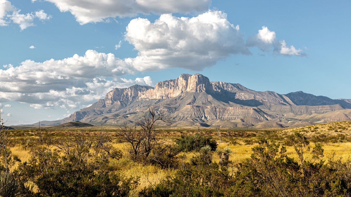
Guadalupe Mountains National Park contains a huge diversity of landscapes and species, also Guadalupe Peak, the highest point in Texas, and the rock tower El Capitan, once used as a landmark by a stagecoach line. The ruins of the Pinery Station for the Butterfield Overland Stage Line show here. (Photo: Education Images/Universal Images Group/Getty)
Want variety? This trip has a trio of national parks that are close geographically, but a world apart in terms of terrain. Carlsbad Caverns National Park is all about the subterranean, protecting 119 caves, the biggest of which are open to exploration. Guadalupe Mountains National Park covers a swath of 8,000-foot peaks in West Texas, and those include eight of the 10 tallest in the entire state. White Sand Dunes National Park is home to a 275-square-mile gypsum dune field that rolls towards the horizon in a series of white tidal waves.
The colors of twilight seep onto the mountain-flanked dunes of White Sands National Park, New Mexico. (Photo: Gary Nored/AnEyeForTexas)
All three parks are within a couple hundred miles of each other, and El Paso serves as an ideal starting point to fly into the area and rent a car. These parks don’t see the crowds that some of the big-ticket units draw in summer, so there’s a better chance for quiet and good campsites. The three also have totally different climates. White Sand Dunes is hot (but not like J-Tree or Death Valley), Carlsbad is underground, and Guadalupe is chilly.
Other than a brief period where you skirt around the edge of El Paso, you’re driving mostly two-lane highways with a real “middle of nowhere” vibe between the parks. Think sand and scrub brush for as far as the eye can see.
White Sands Loop via Alkali Flat Trail (Photo: Courtesy Gaia GPS)
Adventures in White Sand Dunes: Alkali Flat Trail is a five-mile loop through the heart of the sand dunes, following red trail markers. You’re climbing and descending 60-foot dunes the entire time, so pace yourself and expect your legs to be worked at the end. Bring a sled (sold at the visitors’ center if you don’t have your own), as you’re allowed to slide down the steepest slopes along the route.
Adventures in Guadalupe Mountains National Park: The signature adventure is hiking the 8,751-foot Guadalupe Peak, with a craggy, treeless summit, the tallest in the state of Texas. The views stretching east over the plains are endless, but to earn them you will climb 3,000 feet in just over four miles. Bring a jacket, as the summit is notoriously windy. But the real treat of Guadalupe Mountains is Devil’s Hall Trail, a four-mile out-and-back that’s rocky with mandatory scrambling to traverse a dry river wash. Towards the end, you’ll climb Hiker’s Staircase, an easy hand-over-hand natural rock ladder out of the wash and into a narrow slot canyon.
Switchbacks lead down to the Natural Entrance to Carlsbad Cavern, adding distance and atmosphere to your hike through the (very) Big Room. (Photo: Courtesy Peter Jones/NPS)
Adventures in Carlsbad Caverns: Start with a self-guided tour of the Big Room, the largest single-cave chamber in the U.S., loaded with bizarre stalactites and stalagmites. An elevator could deliver you into the cave, but instead walk the switchbacks down via the Natural Entrance, and feel what it’s like to go from the surface into the cold, dark underground. The full hike down the Natural Entrance and into the Big Room is 2.5 miles and should take a few hours; without the walk in, the hike is 1.25 miles, with a .6-mile shortcut also possible, and parts of the Big Room are wheelchair accessible. If you want something spicier, sign up for a ranger-led tour of Lower Cave, which requires descending 60 feet of ladders and ropes to a series of smaller rooms with crazy rock features, like the skinny, tall “Texas Toothpick” or “cave pearls,” which look like clusters of eggs ($20, reservations required).
Sherwood Forest, in the Left Hand Tunnel of Carlsbad Caverns, as seen by lantern (Photo: Courtesy Peter Jones/NPS)
Where to Stay: Guadalupe Mountains National Park and Carlsbad Caverns are close enough that one campground works as a base camp to explore both. Check out Pine Springs Campground in Guadalupe Mountains, which has 20 tent sites and 13 RV sites you can reserve in advance ($20 a night). A number of hiking trails (including Devil’s Hall) begin here. The closest campground to White Sands is in Oliver Lee Memorial State Park, which has private desert sites ($10 per night). The backcountry campsites in White Sands are closed indefinitely, but nearby Alamogordo has a variety of chain hotels.
4. Denali National Park to Kenai Fjords National Park
Alaska
Distance: 400 miles
Duration: Five-plus days, but if you’re flying all the way to Alaska, take your time
Bike up to Sable Pass for views all the way to Denali, yet also of the wildlife nearby. (Photo: Courtesy Bike Denali)
Alaska is an awe-inspiring collection of giant mountains, permanent ice fields, and jagged coast, and Denali and Kenai Fjords national parks encapsulate choice slices of that unique topography. Denali National Park covers more than 6 million acres of Alaska’s interior, including the 20,310-foot Denali, but also the tundra and spruce forest that surround it and attract big-time wildlife like caribou and brown bears. Kenai Fjords National Park couldn’t be more different; instead of forest and towering peaks, it’s home to 600,000 acres of glaciers, inlets, bays, and islands. More than half of the park is covered in snow and ice year round, and the majority is accessed by water. While much of Alaska isn’t conducive to road trips because of a lack of roads, these two parks are less than 400 miles apart and connected by highways.
Chugach State Park is a hiker’s paradise. This viewpoint is on the Williwaw Lakes Trail, extending five miles to a series of alpine lakes below the 5,000-foot Chugach Mountains. (Photo: HagePhoto/Getty)
The two-lane blacktop between the main destinations rolls out like a highlight reel of Alaska, offering views of Denali’s snow-capped peaks at one point and the Cook Inlet at another. Keep an eye out for Beluga whales, which live and breed in the inlet. Chugach State Park, with its 3,000-foot mountains, is also on the route.
A visitor can fly into Anchorage, halfway between the two parks. You’ll basically have to ditch the car at each destination, as car travel is limited in both parks. There are few roads in Kenai, and the main road through Denali is limited to shuttle traffic to minimize impact on the landscape. But that’s part of the charm here.
Denali National Park and Preserve is a jewel amid some of the wildest landscapes in America. (Photo: Sterling Lanier/Unsplash)
Adventures in Denali: Denali isn’t a “drive through” park. In fact, private vehicles aren’t allowed past mile 15 of the scenic Denali Park Road, though bikes get the green light. To ride in, start at the Savage River Visitor Center (mile 15) and bike to Sable Pass between miles 37 and 42, where the final 1,500-foot climb to the pass is rewarded by views that stretch all the way to Denali itself. But Sable Pass is best known for its wildlife. Mostly treeless and full of berry bushes, it attracts brown bears, caribou, and Dall sheep, which often graze in the tundra near the road. From the top of the pass, you can turn around and bike back, or, if you pre-arrange it, hop on the free Savage River Shuttle, which has bike racks. Bike Denali offers rentals (starting at $75 per day).
Or consider a guided rafting trip on the Nenana River, a glacier-fed stream that forms the eastern border of Denali. Book a mild or wild day trip with Denali Raft Adventures. The 11-mile canyon run is packed with class IV rapids with names like “Coffee Grinder,” and the full ride, for ages 12 and up, is a brisk two hours. A different short option, the two-hour-long Wilderness Run, is ideal for young families, as it contains mostly class I-II rapids and offers a good chance to see wildlife like moose and caribou. (From $130 a person, May through September).
Adventures in Kenai: Kenai is a coastal park with most of its goods accessed via boat, but land lovers have options, too. Hike on the edge of the Harding Ice Field, the largest permanent ice field in the U.S., stretching for 700 square miles and feeding Exit Glacier, which forms a half-mile-wide river of ice that melts into Exit Creek. Start at the Exit Glacier Nature Center and hike the 8.2-mile out-and-back Harding Icefield Trail, which climbs a total of 3,000 feet through the surrounding forest to gigantic views of the icefield. If you really want to throw yourself into the landscape, book an intro-to-ice climbing trip with Exit Glacier Guides, exploring crevasses and climbing pitches of vertical ice with use of rope, crampons, and axes ($249 per person).
Exit Glacier via Harding Ice Field Approach Trail (Photo: Courtesy Gaia GPS)
For a water-borne adventure, head to Bear Glacier Lagoon, 12 miles south of Seward, where a thin beach separates a glacier-fed lake from the Gulf of Alaska. The lake sits in a deep bowl rising to green ridges, and the water is littered with house-sized icebergs. Liquid Adventures offers fully outfitted day trips to the lagoon ($550 per person).
A day spent in the deep-blue Bear Lake Lagoon, Kenai Fjords National Park (Photo: Courtesy Liquid Adventures)
Where to Stay: In Denali, book a spot at Savage River Campground, which has 32 sites tucked into a spruce forest ($49 a night). Located on mile 13 on the Denali Park Road, it’s easy to reach with a car (some campgrounds in Denali are only accessible by shuttle bus), but the real prize is access to Savage River and incredible views of Denali via a short gravel-road walk. Reservations are recommended, but not required. In Kenai, Exit Glacier Campground has 12 walk-in tent sites, first-come, first-served. They’re free, but fill up most nights during July and August. The Seward Adventure Lodge, in the middle of downtown Seward, is a seven-room mid-century-era motel with renovated rooms located just minutes from the edge of Kenai ($190 per night, two night minimum).
5. Mesa Verde and Black Canyon of the Gunnison National Parks
Colorado
Distance: 160 miles
Duration: Three days
Peer into well-preserved, 700-year-old cliff dwellings in rock alcoves at Mesa Verde. Here the Balcony House is seen from the Soda Canyon Overlook Trail. (Photo: Courtesy NPS)
Rocky Mountain National Park gets most of the love in Colorado, and while it’s incredible, the Centennial State has other unforgettable national-park units. Mesa Verde National Park and the Black Canyon of the Gunnison National Park are nestled into the southwest corner of the state, proximal enough to make for an ideal weekend road trip. Mesa Verde is a cultural treasure, containing more than 5,000 archaeological sites, including the early cliff dwellings of the Ancestral Pueblo people.
The grandeur of the Black Canyon of the Gunnison National Park, Colorado (Photo: Starcevic/Getty)
The Black Canyon of the Gunnison is altogether different, enveloping a nearly 2,500-foot-deep gorge surrounding the Gunnison River. It’s a deep, dark chasm with sheer vertical walls, rugged hiking and climbing, boating, and world-class trout fishing.
The iconic mountain town of Telluride, deep in a box canyon, at last year’s Mountainfilm festival (Photo: Alison Osius)
You can fly into Durango to kick the trip off, and Telluride is smack dab in the middle of the route between parks if you want to throw in a visit to a classic mountain town. The Jud Weibe Trail, a locals’ favorite and handy but fantastic afternoon outing, offers views of the ski area and entire valley on varied and forested terrain.
The majority of this road trip cruises through San Juan National Forest on a highway with views of some of Colorado’s tallest and most iconic peaks, including the 14,158-foot Mount Sneffels and 14,023-foot Wilson Peak. You’ll pass right through Telluride, but you can also make a 22-mile roundtrip detour to Ouray to soak in the hot springs.
The roadway between the parks mostly goes through the San Juan National Forest, and offers views of Mount Sneffels (center), one of the state’s most beautiful 14ers, among other famed peaks. Mount Sneffels is located in the Uncompahgre National Forest. (Photo: Courtesy Brendan Bombaci/USFS)
Adventures in Mesa Verde: Get your bearings by driving the six-mile Mesa Top Loop Road, which winds along past excavated mesa-top villages, with overlooks to see cliff dwellings, including the Cliff Palace, which archaeologists believe could house up to 100 people. There are 30 miles of hiking trails inside the park, so you can see a lot of the area in a day. If you’re limited on time, hike the 2.4-mile Petroglyph Point Trail, which will have you squeezing through boulder passages and traversing cliffside singletrack to a large petroglyph panel. To see the cliff dwellings up close, reserve a spot on a ranger-led Cliff Dwelling Tour ($8 per person, reservations possible 14 days in advance). The Balcony House Tour is the most adventurous: you ascend a cliff face into the 700-year-old dwelling via a series of ladders, then worm through a narrow tunnel that connects rooms.
Canyon Descent: Tomichi Route (Photo: Courtesy Gaia GPS)
Adventures in the Black Canyon of the Gunnison: The BCOG is a tough canyon to navigate, as there are no bridges connecting the North Rim and South Rim, so it’s a circuitous two-hour drive between the two sides of the park. The South Rim is the more developed, with a dozen overlooks, a visitors’ center, and an 88-site campground. The North Rim is more primitive, with a gravel road providing access to a few developed trails and a handful of overlooks. Both sides are stunning, but I’m pointing you to the South Rim for its hiking and scrambling routes. If you want to stretch your legs and enjoy the view, stroll the two-mile Rim Rock Nature Trail for shots of the canyon and river below. But you’re here for the scramble to the bottom of the gorge via the unmarked Tomichi Route, which drops 1,960 feet in just one mile (the park allows use of the trail and offers a video about it). There’s a lot of down climbing and loose rock, but at the bottom you’ll have the Gunnison River all to yourself. Bring a fly rod; the Gunnison is a gold-medal trout stream. This is a full-day adventure, and you’ll need a permit (free) to descend into the canyon. Get one at the South Rim Visitor Center.
A rafter portages a section during a trip from East Portal to Gunnison, Black Canyon National Park, Colorado. The river is also famed for fly fishing and float fishing. (Photo: Courtesy NPS)
Where to Stay: Both parks have large campgrounds, if you want to keep it simple and budget friendly. The Black Canyon of the Gunnison’s South Rim Campground is convenient (only a mile from the visitors’ center), but don’t expect a ton of privacy ($20 a night, reservations recommended). The North Rim has a smaller campground, with 13 sites separated by piñon and juniper trees ($20 a night, first-come, first-served). Morefield Campground, in Mesa Verde, is large, with 267 sites within a broad, grassy canyon ($38 a night, reserve in advance).
If you want to spend a night in Telluride, check out The Bivvi, an upscale hostel with private or shared rooms that caters to road trippers (from $40 per night).
Graham Averill is Outside magazine’s national parks columnist. He’s currently trying to convince his 15-year-old twins to re-create the national parks road trip they undertook a decade ago. It’s not going well.
The author, Graham Averill, in Joshua Tree National Park (Photo: Liz Averill)
For more by this writer:
The 9 Most Fun Adventure Lodges in North America
The 9 Best Gateway Towns to U.S. National Parks
The 8 Most Adventurous States in America. Number 1 Is …
11 Remote Destinations That Are Definitely Worth the Effort to Visit
The post The 5 Best National Park Road Trips in the U.S. appeared first on Outside Online.